Morning Branch
Great Wildlife Habitat
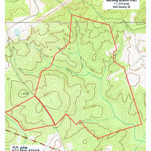
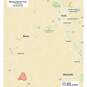
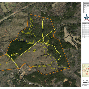
Morning Branch is an outstanding recreation property with exceptional diversity of wildlife habitat. The land lies north of McConnells Highway in a quiet area of western York County, about equal distance from McConnells and Sharon.Diversity is abundant across the landscape. Upstream waters are clear, cool and rocky. Downstream, creek bottoms are wide, flat, and filled with hardwoods and grassy glades. Uplands are rolling hills covered by a mix of old and young planted pines. Steeper slopes overlook the creek bottom in places.
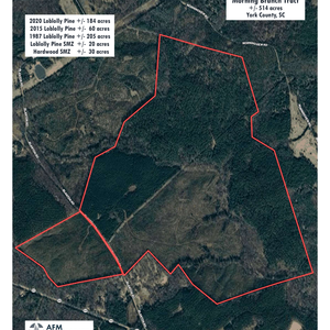
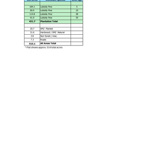
About 205 acres lying on the eastern side are forested with loblolly pine planted around 1986 and 1987. About 60 acres of pines were planted in 2015 and about 184 planted in 2020. These young trees are healthy and growing fast. Blackberry, grasses and other wildlife food sources are common. Deer are abundant, turkeys are common, and quail have been seen in the youngest pine stand.
There is small distribution powerline which, more or less, bisects the property. Above this line the hills are more strongly rolling and uplands are dominated by pine. There are some flats with hardwoods such as yellow poplar in patches along the creeks, but most stream bottoms are narrow. Mature pines are thin on some of the ridges, allowing for younger trees mixed with grassy areas. Two small branches flow through this area, both are gravely and rocky. One appears to typically flow year-round while the other is more intermittent.
The two branches join just south of the little powerline. Below this point, the pine hills are more gently rolling, and the creek bottom is very broad and level in places. Hardwoods such as sweetgum, maple and sycamore are common on about 30 acres of floodplain. Wood duck boxes stand along an area where a series of now-abandoned beaver dams used to keep an area flooded. There is potential to restore and manage this area as a waterfowl impoundment. Much of this bottomland is classed as wetland by the USFWS National Wetlands Inventory.
Access across the land is good with internal roads and trails. Small openings of around a quarter to half acre each are scattered along the roads. These are mostly sites used as logging decks that have kept as open wildlife areas. Soils are productive for timber and wildlife openings. Over parts of the property, soils would be productive for larger fields and pastures if desired.
Blanton Road is a small, paved county road which runs through the tract for more than 1,700 feet giving frontage on each side. Topography is gently rolling near the road where several acres are classed as useful farmland (USDA prime farmland) and soil maps indicate that septic perc potential is good. A powerline along Blanton Road is maintained by York Electric Cooperative and Comporium offers high-speed internet. There are no public waterlines nearby. The immediate neighborhood is mostly large wooded tracts. Houses are widely scattered in the area. A prominent hill with easy access offers long-range views over the creek valley looking east.
The town of York is about a 20-minute drive away and offers restaurants, doctors, churches, and stores. There are local favorites like Garden Café, York Coffee Roastery, Black’s Peaches and Bush-n-Vine farm store, and chains including Tractor Supply, Lowes, and Food Lion Grocery. The tract is about 8 miles from either McConnells or Sharon, 13 miles from York, 21 miles from Rock Hill, and 46 miles from Charlotte. All distances are approximate road miles to the center of town.
**There is an active hunt lease on this property. Please do not visit without first contacting the agent.
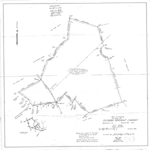
A plat from 1980 describes the tract as 514.31 acres. The property is timberland with no improvements and does not have an address. It is on Blanton Road (GPS = “Blanton Rd, Sharon, SC 29742”) about a half mile north of its junction with Hwy 322 / McConnells Highway.
County tax map # 2150000002.