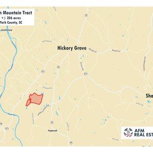
Worth Mountain
Joins public land along river
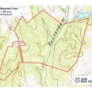
Worth Mountain Tract is an exceptional timber and recreation property located in the quiet hills of western York County. It lies a few miles southwest of the small town of Hickory Grove on Scenic View Road.Broad upland ridges are covered with young and mature pine forests. Beaverdam Creek is a perennial stream flowing through the land for more than 2,000 feet. Boulders and rock outcrops are found along the creek and small tributaries. Patches of hardwood stand along the creek and on hillsides. The immediate neighborhood is mostly wooded tracts and pastures. Houses are widely scattered in the area.
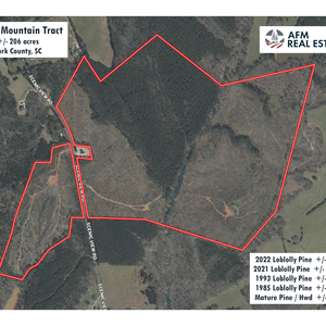
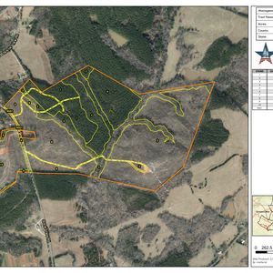
The land is all forested except for woods roads and a few small openings and trails. Soils are mostly sandy clay loam or clay loam and productive for timber and wildlife openings. About 125 acres are covered in loblolly pine now 3 or 4 years old. These trees are healthy and growing fast. About 46 acres of pines are 30 to 40 years old.
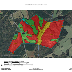
More than 40 acres of these pine stands are classed as useful farmland (USDA soil class prime farmland). These areas could be productive for larger openings and pastures if desired. Some of the bottomland areas along Beaverdam Creek could also be used for small fields, orchards or gardens, but occasional flooding occurs on these soils.
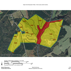
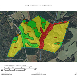
Scenic View Road is a rural 2-lane highway. About 30 acres lie west of Scenic View Road with good access and a potential building site on a prominent hill. Around 175 acres lie on the east side of the road. Topography along the road is gentle and easily accessible in most places. Multiple building sites can be found on gentle terrain near the road frontage. Soil map for septic drain field potential looks favorable in these areas. Powerline and fiber optic cable are present along the road. There are no public waterlines in the area. A home would require well and septic.
Worth Mountain Wildlife Management Area is a 1,643-acre area of public land owned by York County and leased and managed by South Carolina Department of Natural Resources. The WMA shares common boundaries with the property and lands are open year-round daylight hours. The WMA has long frontage on Broad River and provides river access via Dalton’s Landing. This small parking area and river ramp lie at the end of Dalton’s Landing Road just over a mile from the tract’s south boundary. Public dove fields are located along Dalton’s Landing Road. Closer to the property, the WMA’s 4-acre Horseshoe fishing pond comes within about 100 feet of the tract’s southwest corner. Adjacent landowners can walk to the pond though the woods or use the gravel access road which leaves Scenic View Road about 600 feet from the south property line. State fishing license is required for use of the pond. Special WMA rules may apply to hunting activities in addition to general licenses and game zone rules. The WMA also offers hiking trails including a walk to the top of its namesake Worth Mountain.
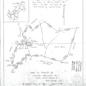
The highest point on the property is a rocky knoll near the southwest corner which sits at just over 600 feet elevation. A small, old family cemetery is found in an area of mature pines near the center of the tract on a hill just west of Beaverdam Creek. A plat from 1980 describes the tract as 211.0 acres.
The town of York is about a 20-minute drive away and offers restaurants, doctors, churches, and stores. There are local favorites like Garden Café, York Coffee Roastery, Black’s Peaches and Bush-n-Vine farm store, and chains including Tractor Supply, Lowes, and Food Lion Grocery. The tract is about 4 miles from Hickory Grove, 16 miles from York, 31 miles from Rock Hill, and 54 miles from Charlotte. All distances are approximate road miles to the center of town.
**There is an active hunt lease on this property. Please do not visit without first contacting the agent.
The property is vacant timberland and does not have an address. A neighbor’s home sits on about an acre along Scenic View Road that is surrounded by the property. This house is at 1741 Scenic View Rd, Hickory Grove, SC 29717. Gates enter the property to the north, south and across the paved road. See attached location map. County tax map number is 017-00-00-004.